Was Giza under the sea?
A thread · A flood theory, the cap of Khafre’s pyramid and the Sahara
A theory going round says a shift in the Earth’s rotation sent the sea 576 feet up over Giza, and that the top of Khafre’s pyramid is the proof. It is a blog hypothesis, not a finding. This page records it, claim by claim, and says what the record shows for each.
- First published
- 2020, on a blog
- Claimed waterline
- 576 ft, about 176 m
- Peer review
- none
- Type of connection
- unresolved
- Open questions
- 4 logged
Is there evidence that Giza was under the sea in the last 12,000 years? Not in anything I found.
The theory is a self-published blog hypothesis. It has not been peer reviewed, and the author describes the theory as solely his own work. I collect theories on this site, including ones I cannot support, and mark where each stands. This one stands at: proposed, untested, and contradicted by several measurements I could check.
The theory, as I understand it
A pseudonymous blogger who writes as The Ethical Skeptic proposes that the Earth’s outer shell can swing into a new rotational state, because the core decouples from the mantle. The theory is called ECDO. An AI-written Grokipedia page expands it as Exothermic Core-Mantle Decoupling Dzhanibekov Oscillation; I could not find the expansion in the blog posts I read, so treat it as unconfirmed. The idea is that the oceans would slosh across the planet and flood continents, and the author links this to flood myths around the world. His own article says the first hypothesis was published on 16 February 2020, and a 2026 post cites his book on the theory.
Giza is his showcase. A 2 November 2026 post argues that the banded erosion on Khafre’s pyramid was cut by the sea, with a waterline 576 feet (about 176 metres) above today’s sea level, and credits the mechanism to Roger B. Cunningham, whom it describes as a systems engineer and lifelong sailor. A video that circulates summarises it like this: the little cap of casing at the top stood above the water, the middle layer of soft Tura limestone was stripped and dissolved, and the harder core underneath is what we see now.
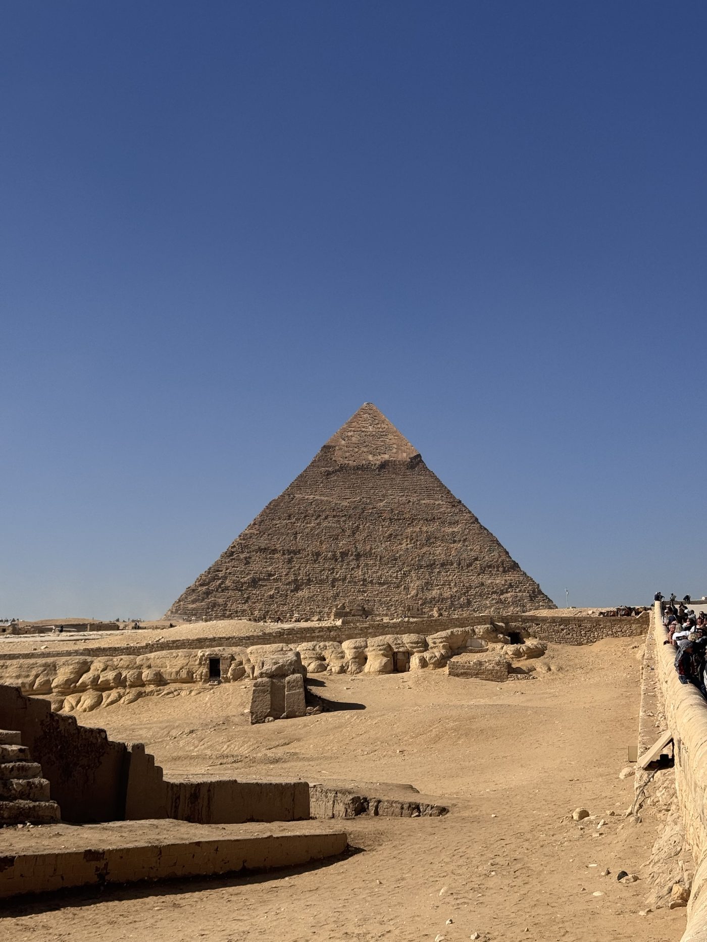
The claims and the replies
| Claim | Who | What the record says, and where it comes from | Status |
|---|---|---|---|
| Khafre sits highest on the plateau, so only its tip would stick out of the water | The video | Khafre’s pyramid stands on bedrock about 10 metres higher than Khufu’s, which is why it looks as tall (Wikipedia). The plateau is about 60 metres above sea level (Wikipedia). On the post’s own 176 metres, my arithmetic, the plateau would lie roughly 115 metres under water. | True premise, untested consequence |
| The missing casing was stripped by waves, not by people | The Ethical Skeptic and Cunningham | Lehner says casing stones at Giza began to be stripped in the reign of Tutankhamun, around 1336 to 1327 BCE, and that this went on until the 12th century CE; an earthquake in 1303 CE loosened some (Live Science, citing Lehner and the BBC). Wikipedia says it is not known when the rest of Khafre’s casing was robbed, and that it was presumably still in place in 1646, when John Greaves described the surface as smooth except on the south side. The video itself uses human quarrying and reuse for the blocks lying on the ground. | Human removal is documented; the date is partly uncertain |
| The Tura casing dissolved underwater, the cap stayed dry | The Ethical Skeptic | The post gives Tura limestone a Mohs hardness of about 3 and a slake durability index under 85, and the Mokattam core 4 and 95. I did not check these figures. The paper it cites for rock properties, Hemeda and Sonbol 2020 in Heritage Science, names rising groundwater from irrigation canals, urbanisation, weathering and an earthquake as the problems; its abstract does not mention flooding or the casing. | Unverified numbers, other mechanisms available |
| The patterns are karst, which is what seawater does to limestone | The video | Karst is the dissolving of limestone by carbonic acid, and the textbook I read ties the acid to rain and snow, with surface water and groundwater carrying it through the rock. It does not need a sea. How far weathering on Giza limestone is rain, salt or something else is the argument in the Sphinx section of the Giza dossier. | Karst is real; a sea is not required |
| Salt crusts on the outside of the pyramid show seawater | The video, citing an Internet Archive clip | I could not find or view the clip. The Ethical Skeptic’s post does not mention salt, and Hemeda and Sonbol’s abstract does not either. Salt on its own does not say where the water came from. | Unverified |
| Dissolved limestone had to be cleared from the Great Pyramid’s descending passage, and a deposit was removed in 1928 without sampling | The video and the post | I found no source for either statement. | Unsupported: no source found |
| The shift drained the water across the Sahara and wiped out any cities | The video | The sources I read describe a green Sahara from about 11,000 to 5,000 years ago, driven by the Earth’s orbit and the monsoon. Dust records show the end coming within one to two centuries in places, and slowly in the eastern Sahara. The people were nomadic hunters turning to herding, who left rock art and moved towards the Nile between about 7,000 and 5,000 years ago (Nature Scitable). I found no source for cities. | Climate explains the Sahara; cities unsupported |
| The rotation was worked out from the alignments of ancient sites | The Ethical Skeptic | The AI-written page says more than 200 monuments and a shift of about 104 degrees; I have not checked that against the author’s own writing. Measured true polar wander runs at about 1 degree per million years or slower, with no rapid shifts in the last 200 million years (a mirror of Wikipedia’s “Pole shift” page, whose text had stray unrelated sentences, so check the original). Hapgood proposed crustal shifts in 1958, and the analysis I read does not support them. | Contradicted by the measurements I found |
| The sea stood 576 feet above today’s level at Giza | The Ethical Skeptic | Earlier estimates put peak Pliocene sea level at about 20 metres above present, and a 2019 Nature study limits the maximum to under 25 metres (Grant and colleagues). 576 feet is about 176 metres. The sea did once reach the Giza area: Wikipedia says the plateau’s relief appears to result from an Early Pliocene marine transgression, millions of years ago. | Far beyond any sea level in the record I found |
The Grokipedia page is written by an AI and names no human author; I used it only for the theory’s name and the figures it attributes to the author, and say so each time. I read the first 100,000 characters of the long 2023 post “Hidden in Plain Sight”, so parts of it, including its sections on sea level, were not read.
Part two: the sloshing, the drains and the alignments
A second part of the same video makes a further set of claims. Same method: what the record says, and where I found it.
| Claim | Who | What the record says, and where it comes from | Status |
|---|---|---|---|
| Egyptian priests told Herodotus they had been through four of these events | The video | In Godley’s translation of the Histories (2.142) the priests count 341 generations, 11,340 years, and say that “four times in this period (so they told me) the sun rose contrary to experience; twice he came up where he now goes down, and twice went down where he now comes up”. In the lines I read, the same passage says Egypt underwent no change in the produce of the river and the land, or in sickness and death. No flood is mentioned there. It is a second-hand priestly account, and what it describes is the sun’s direction. | The passage is about the sun, not floods |
| Mauritania is a huge drain, and drowned cities lie off its coast in the “Mauritania Slag Complex” | The video | I found no “Slag Complex”. I take it to be a slip for the Mauritania Slide Complex, which is my inference. That is a real feature: a submarine landslide on the seafloor of the north-west African margin, covering about 34,000 square kilometres with a run-out of more than 300 kilometres, headwall scars 25 to 100 metres high in 600 to 2,000 metres of water. The authors presume the main trigger was excess pore pressure from decayed organic matter and/or sea-level rise, with failures starting on slopes under about 2 degrees (Antobreh and Krastel, 2006 conference abstract). The abstract gives no ages and no cities. I found no source for cities in it. | A real landslide; cities unsupported |
| The sloshing water left flow patterns in Egypt and Saudi Arabia | The video | I found no source for these patterns, and the video part I have does not say which ones. | Unsupported: no source found |
| About 500 flood legends exist, from Mexico to Rome | The video | The number turned up in my search only as the title of a forum thread, which I did not open. I found no primary count. The older Bible origins thread covers flood stories as scholars treat them. Any total depends on what counts as a flood story, and a count says nothing yet about whether the stories share a source, a shared event, or just the fact that rivers flood. | Number unverified |
| The theory explains the three erosion patterns on the Great Pyramid | The video | The post that started this thread is about Khafre’s pyramid. I found no text naming three patterns on the Great Pyramid, so there is nothing for me to test. | Unspecified |
| It explains cities in the sky, like Sri Lanka and Peru | The video | I checked two likely candidates. Sigiriya in Sri Lanka was a palace and fortress built under King Kashyapa I, who ruled 477 to 495 CE, and later became a Buddhist monastery; monks used the rock shelters from the 1st or 2nd century BCE, and the mirror-wall graffiti is mostly 9th and 10th century (Wikipedia). Machu Picchu in Peru was dated by radiocarbon on the bones and teeth of 26 individuals to occupation from about 1420 to 1530 CE, as an estate of the Inca ruler Pachacuti (Burger and colleagues, Antiquity 2021, via phys.org). I did not check other Peruvian sites. Both are far younger than the flood the post appears to date to about 11,600 years ago. | Dated to historical periods |
| 85 per cent of ancient temples are aligned to this North Pole, from passage mounds in England to every pyramid in China | The video | The closest published figure I found is Mark Carlotto, Journal of Scientific Exploration 34(2), 2020. An earlier study of more than 200 sites left 95 alignments unexplained. Carlotto’s model, built on Hapgood’s crustal displacement idea, accounts for all but 17 of those 95, which is 78 sites, or just over 80 per cent of the unexplained ones. By my arithmetic that is under 40 per cent of all sites studied. The model uses four former pole positions (Hudson Bay, Greenland, Norwegian Sea, Bering Sea), fitted by an algorithm on more than 50 sites, not one pole. Orientations were measured in Google Earth. The abstract does not mention ECDO, and I found nothing about English passage mounds or Chinese pyramids. | Figure garbled; the real paper is narrower and not about ECDO |
| “Juno on X” has released four research papers and makes simulations; a survival field guide exists | The video | I could not identify “Juno”. A public GitHub repository, sovrynn/ecdo, calls itself “a thoughtbank for brainstorming the ECDO thesis” and lists papers by its owner, Sovrynn, including one titled “Civilian’s Guide to ECDO Survival”. I cannot tell whether that is the same person, or the same guide. Its contribution guide says that “almost anything that could potentially be used to justify an ECDO event belongs there first”, which describes a collection of support, not a test. I found no sign of peer review. | Unidentified; not peer reviewed as far as I found |
I read the Herodotus passage, the conference abstract and the journal paper directly or as excerpts, and the repository front page only. The repository’s papers, the video and the author’s own posts on alignments I did not read.
Where the argument meets dated history
If the casing below the cap was dissolved by a flood, the pyramid was already built when the flood came. The post says it “took mankind 11,600 years” to reach this explanation, which I read as dating the flood to about 11,600 years ago, around 9600 BCE. On that reading Khafre’s pyramid would be more than 11,600 years old. The Giza dossier describes Merer’s logbook from Wadi al-Jarf, a record of shipping Tura limestone to Giza during the building of the Great Pyramid. I did not find where the posts reconcile the two, though I read only parts of them.
The sources are also not fully consistent on when Khafre’s lower casing was lost. Lehner dates the stripping from the reign of Tutankhamun to the 12th century CE, while Wikipedia says the casing was presumably still in place in 1646, when John Greaves described the surface as smooth except on the south side. If it was still there in 1646, it did not dissolve in a flood thousands of years earlier. The date of loss is the question the theory most depends on, and the record I found is thin on it.
What if some of the banding on Khafre’s pyramid and on the Sphinx enclosure records water, and not only people, wind and salt? Not a sea 176 metres deep, just a longer wet history than the standard story allows.
I am speculating about the stone, not about anyone who has written about it. Why it is worth asking: the plateau’s relief is attributed to an ancient marine episode, the Sahara was green until about 5,000 years ago, and the weathering of Giza limestone is still argued over. What supports it: the stone clearly weathers in bands, and the Sphinx erosion debate has geologists on both sides. What speaks against it: the sea level needed is more than seven times the highest I found for the Pliocene, the rotation needed is far faster than measured polar wander, and the casing is documented as removed by people. What would separate the readings: independent dating of the weathered surfaces, analysis of the salts and any debris at the foot of the pyramid by laboratories that did not propose the theory, and a search of old excavation records for the deposit said to be removed in 1928. What stays unknown: what the banding on the casing actually records.
What is still open
What caused the banding on Khafre’s casing?
The explanations on the table are human stripping, an earthquake, and weathering by rain, salt and groundwater. I did not find a published study that dated the banding or tested the flood reading against them, so the question is open in the plain sense that nobody I could find has measured it.
Is there any sign of sea at Giza in the last 12,000 years?
I found none. The limestone itself dates to the Middle Eocene, tens of millions of years ago, which says nothing about the recent past. A sediment or salt analysis would settle it either way.
What were the deposits at the foot of the pyramids, and where did they go?
The post says a deposit was removed in 1928 without sampling. I found no excavation record for it. If a record exists, it is the one document that could test the claim directly.
Does the pole-alignment model beat chance?
Carlotto fits four former poles to the sites and then explains most of the leftover ones. The test that matters is whether random orientations, or fewer fixed poles, would explain as many. I found no published test or critique of that in the sources I could reach, so the question is open as far as I know.
Sources
- The Ethical Skeptic, “The First Scientific Hypothesis Regarding Khafre’s Markings”, 2 November 2026, and “Hidden in Plain Sight”, posted 18 December 2023 and modified 31 October 2026. A pseudonymous blog; not peer reviewed. I read the first 100,000 characters of the second.
- Grokipedia, Peak Shifted State (ECDO Theory). Written by an AI, no human author named; used only for the expansion of ECDO and the figures it attributes to the author.
- Wikipedia, Pyramid of Khafre (height, bedrock 10 m higher, casing, 1646) and Giza Plateau (about 60 m above sea level, Mokattam Formation, Early Pliocene marine transgression). Secondary.
- Live Science, “What did the ancient Egyptian pyramids look like when they were built?”: the stripping of the casing, citing Lehner and the BBC on the 1303 earthquake.
- Hemeda, S. and Sonbol, A., “Sustainability problems of the Giza pyramids”, Heritage Science 8, 8, 2020, abstract via DOAJ. Abstract only; I did not read the paper.
- Fullerton College, Introduction to Geology: Karst, a LibreTexts open textbook.
- Nature Scitable, “Green Sahara: African Humid Periods Paced by Earth’s Orbital Changes” (the page is marked archived).
- Grant, G. R. and others, “The amplitude and origin of sea-level variability during the Pliocene epoch”, Nature 574, 237 to 241, 2019, abstract via IDEAS/RePEc. Abstract only.
- Pole shift hypotheses (Hapgood 1958 and 1970, Flem-Ath 1995, true polar wander rates): read on a mirror of Wikipedia’s page that also contained unrelated inserted sentences, which I ignored. The original should be checked.
- Herodotus, Histories 2.142 to 2.143, trans. A. D. Godley (Harvard University Press, 1920 to 1925), Perseus Digital Library.
- Antobreh, A. A. and Krastel, S., Mauritania Slide Complex, Geophysical Research Abstracts 8, 02383, 2006, EGU conference abstract. Abstract only.
- Wikipedia, Sigiriya (Kashyapa I, 477 to 495 CE, inscriptions). Secondary.
- phys.org, report on the 2021 radiocarbon study of Machu Picchu (Burger and colleagues, Antiquity). A news report; I did not read the paper.
- Carlotto, M. J., “A New Model to Explain the Alignment of Certain Ancient Sites”, Journal of Scientific Exploration 34(2), 209 to 232, 2020, DOI 10.31275/2020/1619, journal page. I read an excerpt; the tolerance used for “aligned” was not in it.
- GitHub, sovrynn/ecdo, front page only.
- The video quoted in the summary of the claims, both parts, was given to me as text. I have not seen it, and I do not name its maker here.
A thread, not a place. Page opened 3 November 2026, extended and last reviewed 6 November 2026. Written from the blog posts, reference pages, abstracts and excerpts listed above; I have not read the author’s book, the video, or most of the papers behind the abstracts. The photo is my own, taken at Giza. If something here is wrong, tell me and it gets corrected on the page with a note saying what changed.